In the course of looking through old photographs and postcards of Glasgow, I realized that the City has a good many Crosses; key intersections and road junctions which, because of their importance, were given the special title of Cross and named after their location. They were often places where people would arrange to meet socially, transact business, or stand and wait, hoping to be hired for work. I thought it would be useful to compile an illustrated list and it also gives us the opportunity to visit many different parts of this great City of Glasgow. Most of the photographs here depict scenes from the first two decades of the 20th Century and the catalogue is by no means complete. There are many Crosses for which I still don’t have suitable images and there may be others within the City boundary of which I am yet unaware. Pride of place in the list is given to Glasgow Cross, as it is the earliest. Thereafter, the list continues in alphabetical order.
Soon after this report was filed, a correspondent wrote in about the Victoria Cross along Byers Road and this prompted further research, resulting in the finding of not one but two Victoria Crosses in Glasgow plus a host of other crosses to add to the list, which now numbers 40 in total, plus Paisley Road Toll. For much of this additional information, I am indebted to William Barr’s excellent book “Ghosts of Glasgow”. A few of the locations illustrated here no longer exist because of redevelopment.
Except where otherwise stated, these photographs and postcards are in the archive, and the text is © Christopher J. Jones.
Glasgow Cross
In the period leading up to the Reformation, Glasgow Cross was known as Mercat ( Market ) Cross after the market that was held there in the wide open space where the four streets met. These were the Tronegait to the west, named after the trone or balance that was installed there for weighing goods, Gallowgait to the east, Street from Mercat Cross to the Metropolitan Church to the north, and Walkergait to the south, the latter named after the waulkers who bleached cloth. Later, the street to the north would be renamed the High Street after the High Kirk and Walkergait would become the Salt Market, after the salmon curing. Glasgow has never been a walled city and the term “gait”, also spelled “gate”, does not refer to a gated entry but instead is an old Scottish word meaning “the way to”. Hence the Briggait is the way to the bridge, in this case the Old Bridge or Brig, Bishop Rae’s Bridge, which was the first major bridge across the Clyde in Glasgow. As Glasgow Cross grew in commercial importance, particularly from the 16th Century onwards, its development surpassed that of the area surrounding the Cathedral. The ingress of London Road, originally called London Street, came much later, in 1824, and opened into the Saltmarket, connecting Glasgow Cross with Great Hamilton Street.

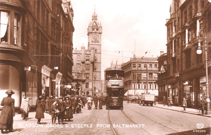
This fine photograph dating from around 1912 shows the view looking north from the Saltmarket towards Glasgow Cross. Perhaps taken early on a Saturday morning, there is a mixed crowd of people out with some family groups and also some men and women on their own. In the foreground, there is a touching scene of a young woman and her baby wrapped in a plaid shawl standing by the kerb. Most of the people are heading up the street towards the Cross, possibly to the Caledonian Railway station and the shops in the Trongate. Tramcar number 774, a “blue” car en route to the Botanic Gardens, is dropping off passengers before turning left into the Trongate. The lorry by the kerb on the right is in the service of MacFarlane, Paton & Co., a firm specializing in jams, jellies and marmalade. It is parked outside the Caledonian Railway Parcels Receiving Office. The single storey building next door is the location for James Coggans’ famous bar “The Coat of Arms” on the corner with London Street. The finely detailed wrought iron lamp standard on the right is serving two roles, both as a light bearer and as a support for the tramwires. It appears to be leaning forward under the tension. At the time this photograph was taken the globes on the lamp standards were in the process of being replaced and newer ones had already been installed at the Cross. ( Postcard published by E. A. Schwerdtfeger & Co., London E. C. and printed in Berlin. )
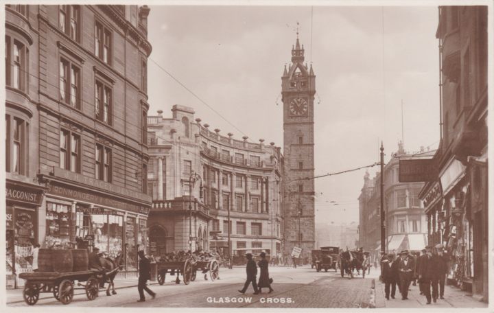
The Mercat Cross at Glasgow Cross
The Mercat Cross, designed by Edith Burnet Hughes and completed in 1929/30, is modest and unassuming compared to the imposing presence of the Mercat Building behind it. It is not a cruciform monument but instead is a column bearing a heraldic unicorn rising from a proclamation platform encircled with a balustrade. This Mercat Cross replaced the original version that had been removed in 1659.
Albert Cross – Located at the junction of Albert Drive and Kenmure Street.
Alexandra Cross – Located at the junction of Duke Street with Cumbernauld Road and East Miller Street.
Anderston Cross – In the traditional heart of Anderston, the Cross was located where Argyle Street divided into Main Street and Stobcross Street. Bishop Street and Washington Street joined Argyle Street just beforehand. Anderston Cross was a very busy transport interchange with access to Anderston railway station underground.
Anderston is situated on the north bank of the River Clyde, to the southwest of the City Centre. Derived from Anderson Toun, the district was named in honor of James Anderson of Stobcross House, who owned the land and let it out for weavers’ cottages in 1725. Bleaching and dyeing were later added to the weaving and, with the Industrial Revolution, the use of steam-driven looms progressively supplanted the handweaving. Engineering, pottery, glass-making, and brewing also took hold in the district and it became an industrial centre. In 1824, when Anderston’s population was around 10,000, it was made a Burgh of Barony and in 1846, when the population had grown to 16,000, it was incorporated into the City of Glasgow.
Anderston Cross was characterized by this very unique, asymmetric building, the left-hand part of which served as entrance and exit for the Caledonian Railway’s Anderston Cross Station, the first station west of Glasgow Central Low Level. The road to the left of the building is Stobcross Street which continues on to Queen’s Dock and Stobcross, as does the railway which runs directly under the street. To the right of the building is Main Street which soon changes into Dumbarton Road.
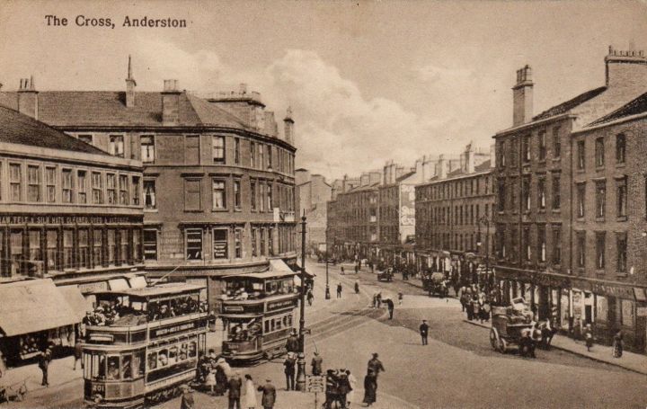
This is the view looking East from the building in the previous photo and along Argyle Street.
Anniesland Cross – Located at the junction of Crow Road and Anniesland Road with Great Western Road.
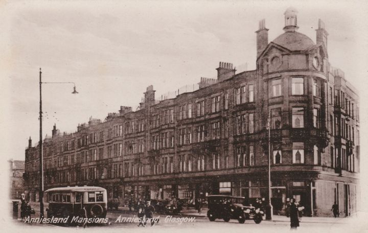
This view probably dates from the early 1930’s and shows Anniesland Mansions which were built at Anniesland Cross between 1907 and 1913 and occupy the corner of Great Western Road and Crow Road.
Baillieston Cross – Approached from the west via Glasgow Road which turns into Main Street. At the Cross, the road branches, and continues as Main Street to the left and Church Street to the right.
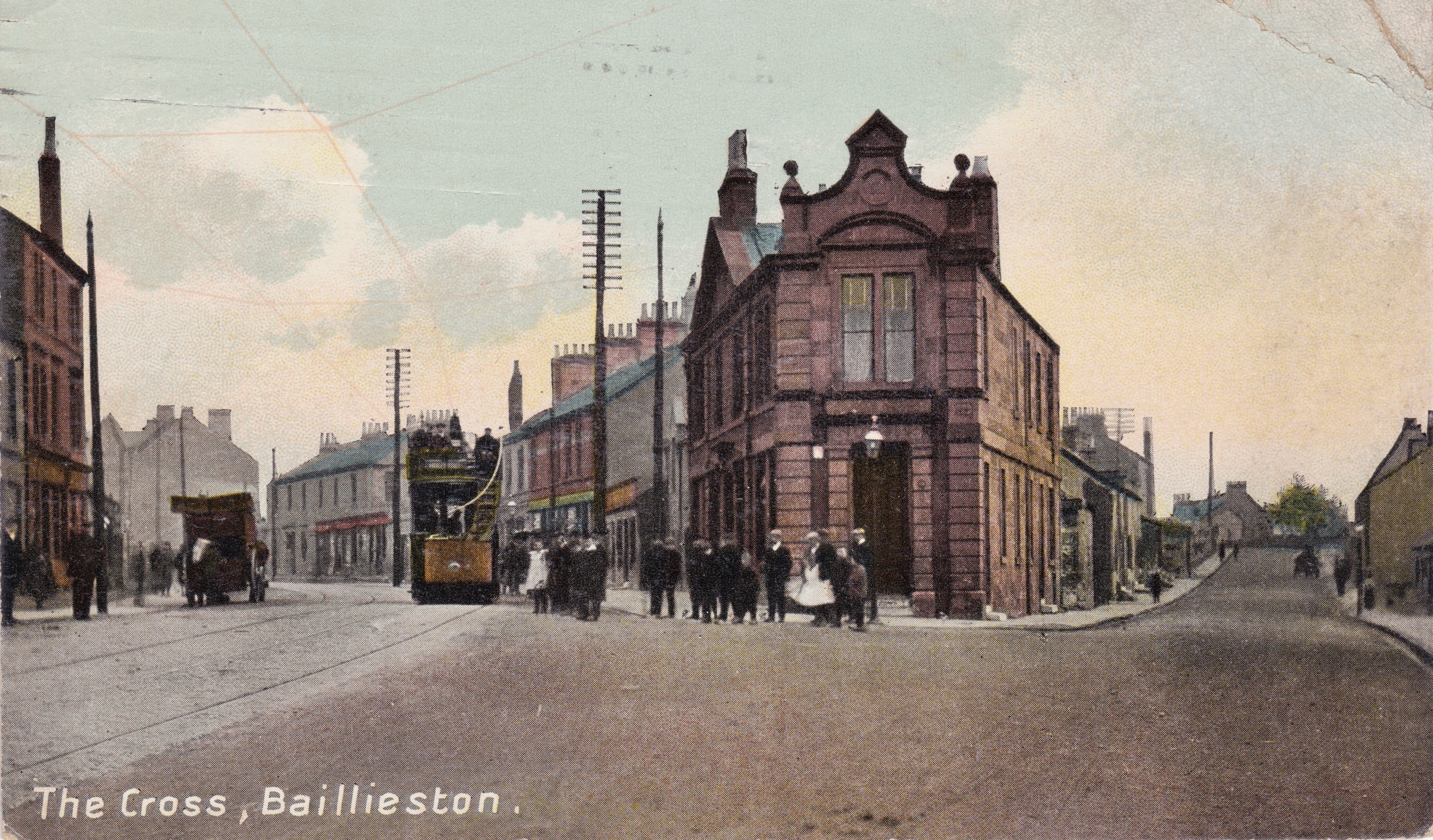
This very early 1900’s postcard was produced by the Wotherspoon Brothers who ran the Post Office in Baillieston. At that time, Baillieston was situated outside the Glasgow City Boundary, in the County of Lanark.
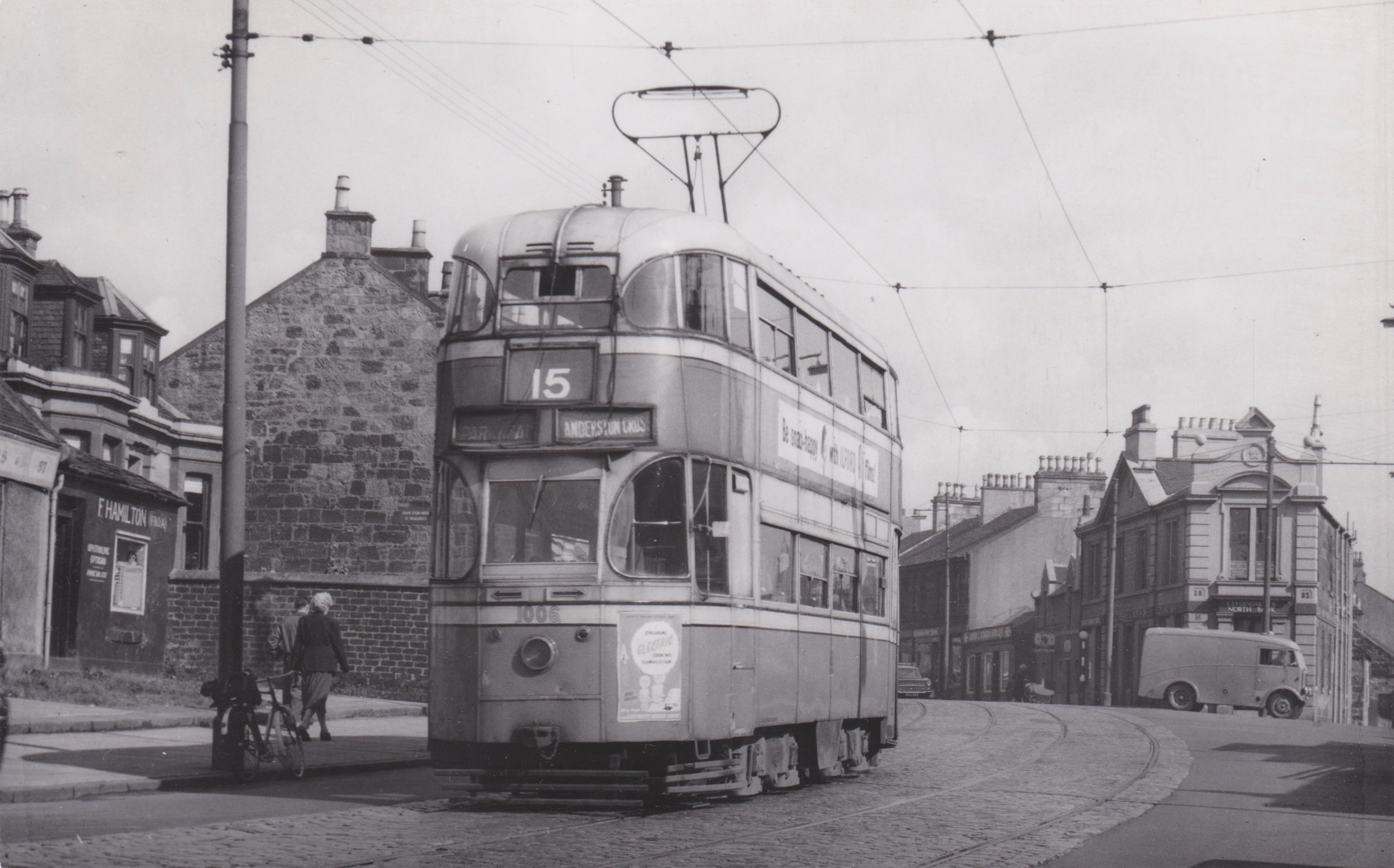
Former Liverpool “Green Goddess” and now Glasgow Corporation tramcar 1005 is seen approaching Baillieston Cross on service 15 from Anderston Cross around 1958. This tram was one of a batch of 46 that Glasgow Corporation purchased from Liverpool for a song in 1953 and 1954.
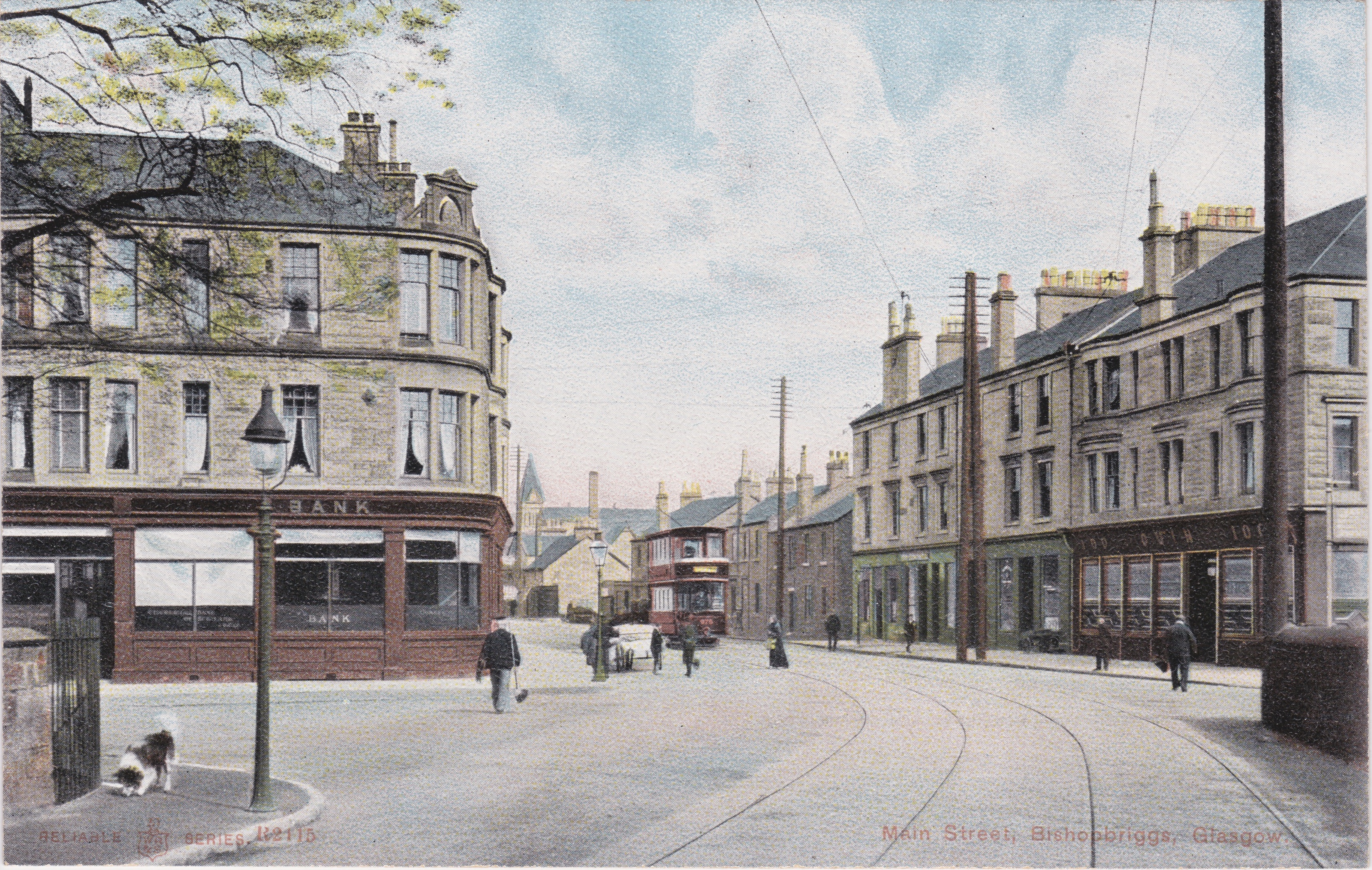
Bishopbriggs Cross – Located at the junction of Kirkintilloch Road with Kenmure Avenue on the left and Springfield Road on the right. Bishopbriggs is outside the Glasgow City Boundary in the County of East Dunbartonshire.
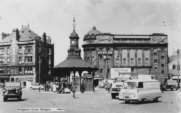
Bridgeton Cross – This is quite an expansive cross where Cannon Street, Orr Street and Charles Street entered at the North End and James Street, Main Street and Dalmarnock Road entered at the South End. Cannon Street has since been renamed London Road, and Charles Street became Olympia Street.
Bridgeton Cross came into being in the early 1870’s as part of the slum clearance program. Before then, it was the location of the Barrowfield Toll, probably established to help recoup the costs of building the Barrowfield Bridge over the Camlachie Burn. The burn was covered over when Bridgeton Cross was developed. Further information on the history of the area may be obtained at http://www.glasgowhistory.co.uk/Books/Bridgeton/BridgetonChapters/BridgetonCross.htm
Bridgeton
Bridgeton, like all other parts of Glasgow, was originally open countryside. The area came to be known as Barrowfield and was administered by the Church until the lands were annexed to the Crown by an Act of the Scottish Parliament in 1587. In 1723, Glasgow Town Council purchased the estate and in 1731 they sold it to John Orr, a city merchant, for £10,000. It was during the Orr family ownership that an opportunity for significant development occurred.
At that time, there were only two ways to cross the Clyde near the town centre, either via Glasgow Bridge ( also known as Bishop Rae’s Bridge which connected the Stockwell with the Gorbals ) or by the ford at Dalmarnock. Using the latter could be hazardous, especially after heavy rains, and in 1765 a partial closure of Glasgow Bridge for urgent repairs led to a crisis, particularly affecting trade between the City and the Royal Burgh of Rutherglen. A new bridge needed to be built and quickly. Rutherglen Bridge, designed by James Watt and connecting the lands of Barrowfield with those of Shawfield, opened in 1776 and was toll-free. Trade increased, the fledgling Barrowfield village expanded in the direction of the new bridge, and subsequently changed its name to Brigtoun, eventually becoming Bridgeton.
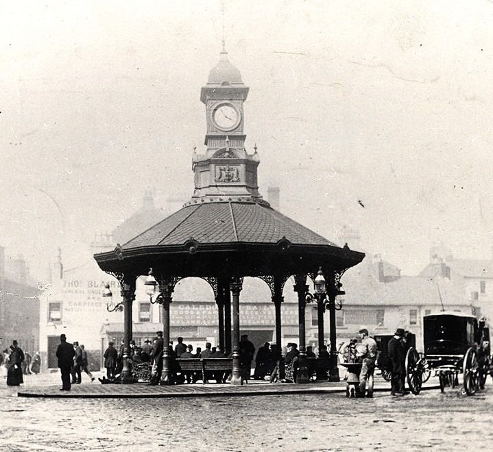
This classic photograph was probably taken soon after the 50 feet high cast-iron Bridgeton Pavilion and Clock Tower was opened at Bridgeton Cross on March 3, 1875. This structure, which came to be known as the Bridgeton Umbrella, has recently been superbly restored. In this scene, the background is occupied by the Caledonian Railway Goods & Parcels Office. It would not be until much later that the Olympia Theatre would be built there, opening its doors in 1911.
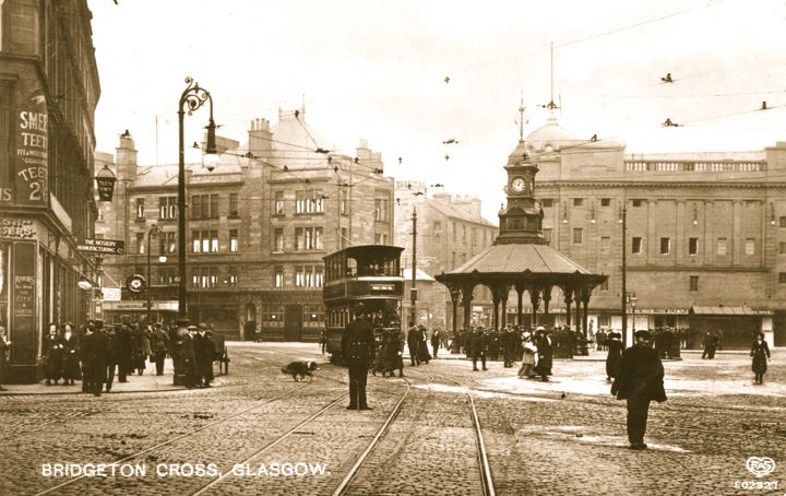
This photograph of Bridgeton Cross, taken around 1912, shows the famous Brigton or Bridgeton Umbrella, with the recently opened Olympia Theatre in the background.
Broomhill Cross
Broomhill Cross is located at the junction of Crow Road with Broomhill Drive.
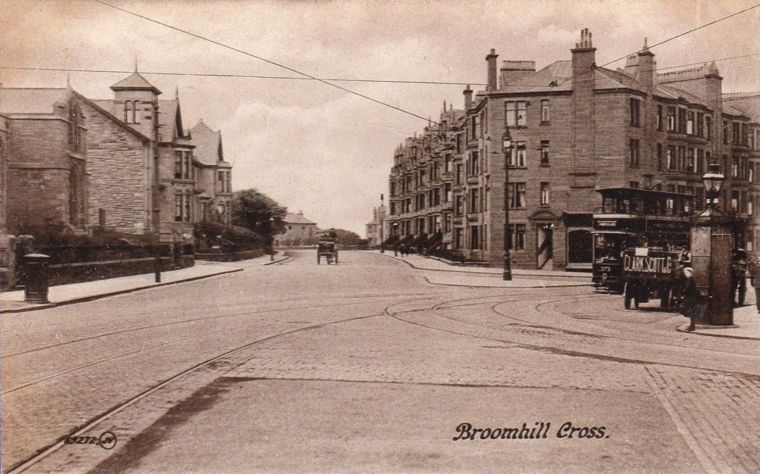
Here, we are looking directly along Broomhill Drive, circa 1911, and the tramcar on the right is coming up from Crow Road. The fine red sandstone tenements in view are relatively new and incorporate a row of commercial premises on the ground floor. The structure with the large gas lantern on top, visible on the far right of the photograph, is a police call box, and Glasgow has the distinction of being the first city in the kingdom to install them, beginning in 1891. The hexagonal structure was made of cast iron and the gas lantern could be activated remotely from the police station, alerting an officer on the beat to call in. The tower in view on the left is actually part of the residence on the other side of Broomhill Gardens from the church. Perhaps it was the manse. It is interesting to note that around 15 years earlier, Broomhill did not exist. This was all open space.
Cessnock Cross – Located at the corner of Edwin Street and Paisley Road West.
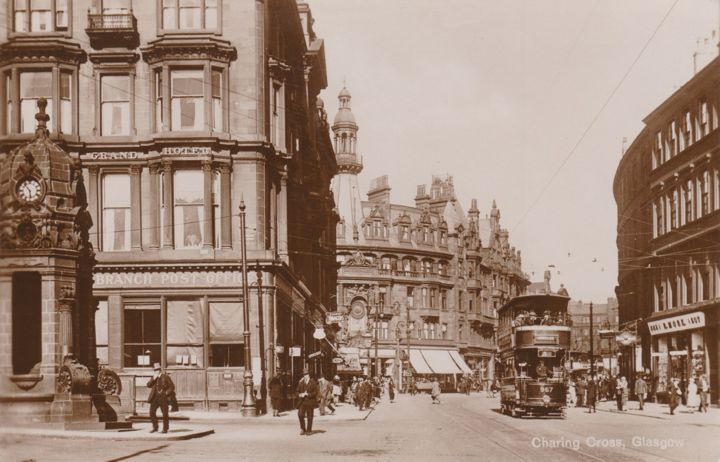
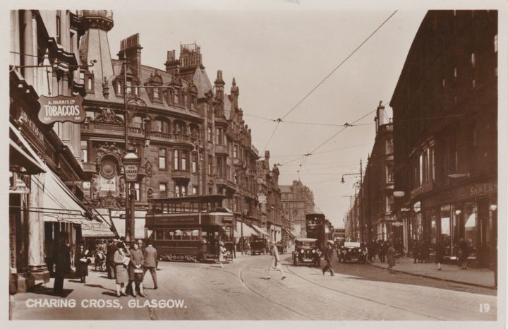
Charing Cross – Located where St. George’s Road joined Sauchiehall Street. Newton Street and North Street also enter nearby.
In searching for the origin of the name Charing Cross, I found in reference to the London location that Charing is derived from the Old English word “cierring”, referring in this case to a pronounced bend in the River Thames, and the Cross in the London version refers to the original location of the Eleanor Cross, a Mediaeval cross in the hamlet of Charing. I have yet to find any reference to the origin of Glasgow’s Charing Cross except to say that it was named after the one in London. Glasgow’s Charing Cross is much further from the River Clyde, where there is a modest bend, than the London version is from the River Thames, where there is a pronounced bend. Perhaps Glasgow’s Charing derives from the marked bend in Sauchiehall Street at that location and the Cross comes from the fact that there is a major junction with St. George’s Road, and also secondary junctions with North Street and Newton Street.
Cowcaddens Cross – Located at the junction of Cowcaddens Road with New City Road and Garscube Road. Ann Street, Stewart Street and Milton Street would join nearby. Also present is Cowcaddens Subway station, convenient for Garnethill, the Glasgow School of Art, and the lower reaches of Sauchiehall Street. Sadly, the cross is no longer recognizable because of redevelopment but the Subway station is still in operation.
Cowcaddens
The name Cowcaddens is thought to derive from a place where cows were pastured. It used to be a village in open countryside at the foot of Garnet Hill, beyond the West Port of Glasgow but everything changed with the coming of the Forth and Clyde Canal, whose path was just to the north and east of rural Cowcaddens. Upon completion in 1790, the canal served as a magnet for light and heavy industries, that set up their mills and foundries beside it. With the influx of industries, there was a need to provide housing for the workers and their families, so residential construction began apace in rural Cowcaddens, transforming it from countryside to cityscape as the 19th Century progressed. In 1846, the area was incorporated into the City of Glasgow.
Finnieston Cross
Although not marked as such on Ordnance Survey maps of the period, Finnieston Cross is where Finnieston Street and Minerva Street join Dumbarton Road.
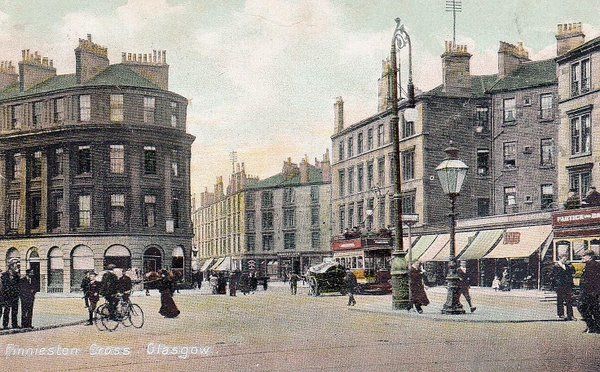
This photograph was taken at the top of Finnieston Street. Minerva Street is to the left. The presence of open top trams on Dumbarton Road would indicate a likely date in the first decade of the 20th Century.
The history of Finnieston dates back to 1768 when Matthew Orr, the owner of the Stobcross Estate, set aside land for the establishment of a new village which he named in honour of his tutor, the Reverend John Finnie.
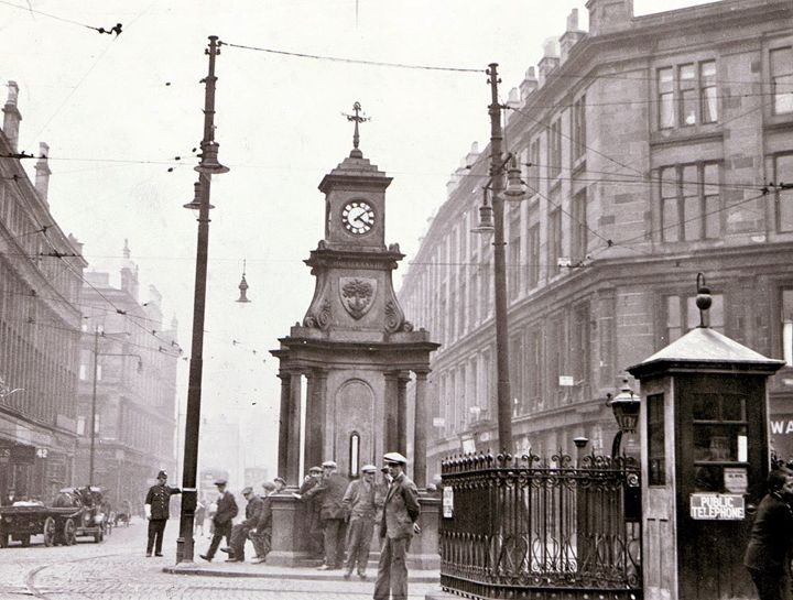
Garscube Cross – Located at the junction of Garscube Road and Possil Road. Fleming Street and St. George’s Road also join at this location. Garscube Cross was known locally as the Round Toll or Garscube Toll.
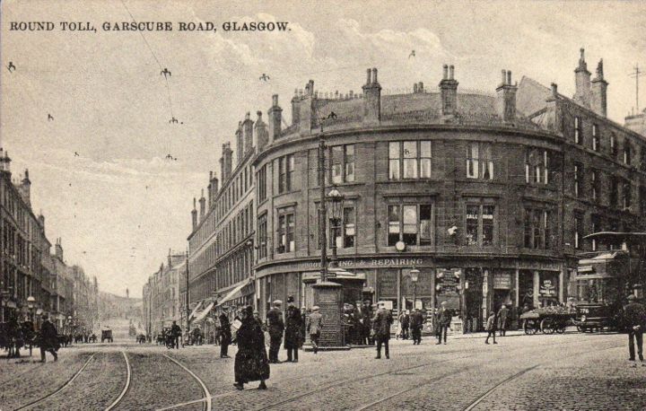
In this view, circa 1913/14, Garscube Road is on the left and Possil Road on the right. St. George’s Road enters on the far left and Fleming Street on the far right, but both are off camera. The tram in view will be going across the Toll behind the island and will probably turn down St. George’s Road, which had the unique distinction of connecting three of Glasgow’s busiest crosses; Charing Cross, St. George’s Cross, and Garscube Cross.
Gorbals Cross
Gorbals Cross is truly cruciform and used to be the junction of Govan Street and Norfolk Street with Main Street. The location has remained the same but two of the streets were subsequently renamed, Main Street becoming Gorbals Street and Govan Street becoming Ballater Street.
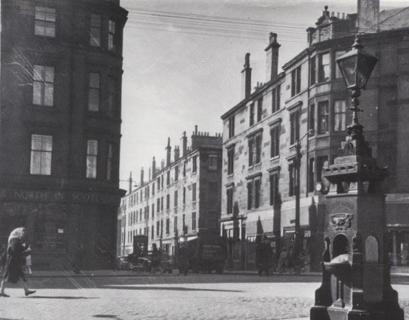
This picture shows Gorbals Cross looking from the east side to the west side, from Ballater Street across to Norfolk Street, and is dated September 1930. The intersection was a very busy one, requiring the presence of the white-gloved policeman to direct the traffic. The drinking fountain and cast iron clock had been erected in 1878 and would be taken down two years after this photograph was taken. Also visible are a public telephone box and wrought iron railings which indicate access to the subterranean gents toilets.
Govan Cross
Govan Cross is situated on the river side of Govan Road between the junctions with Greenhaugh Street and Water Row.
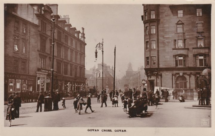
Here, we are looking westward across the “square” at Govan Cross, bounded by Govan Road, Water Row and a lane. In the distance is the statue of Sir William Pearce and the Lyceum Theatre. This photograph was taken around 1913 and there are several groups of working men to be seen as well as some children. Perhaps it was around midday or during the school holidays and the men were either on a break from work or waiting to see if they would be hired. Similar scenes have been recorded at Glasgow Cross and Bridgeton Cross where large numbers of men would gather.
The very fine building on the right has been preserved, as has the Aitken Water Fountain on the far right of the picture. This has recently been superbly restored and is the sole surviving example of the highly decorative, cast iron drinking fountains manufactured by Cruikshank & Co. at their Denny foundry in Stirlingshire. The fountain honours the memory of a local GP, Dr. John Aitken, who is said to have died from overwork, attending to the medical needs of the poor people of Govan.
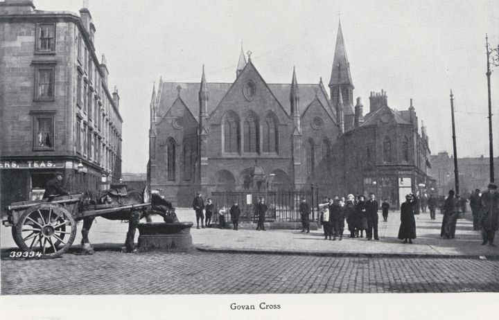
In this scene, dating from 1903, the photographer is standing outside the very fine building at the head of Water Row and looking eastward across the “square” to the United Free Church and Hall on the other side. The Aitken Fountain can just be made out beyond the iron railings. Note the horse on the left, quenching its thirst from the trough.
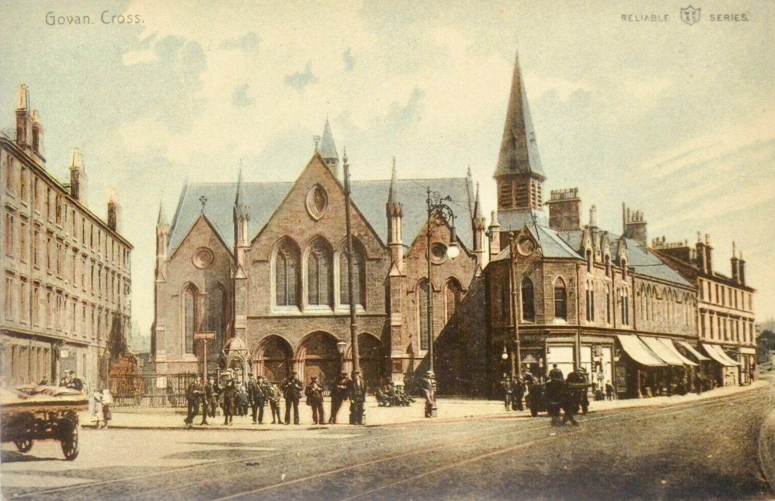
A very fine, coloured view looking eastward to the United Free Church and Hall, as well as some buildings along Govan Road. This particular postcard, published by William Ritchie and Sons, Ltd. ( WR&S ) in their Reliable Series, is postmarked September 20, 1909. I have seen another printing of this scene, postmarked 27th April, 1905.
King’s Cross I
King’s Cross in the East End of the City was located at the junction of Duke Street with Bellgrove Street and Westercraigs.
King’s Cross II
King’s Cross, south of the River Clyde, is located in Govanhill.

A view of King’s Cross, Govanhill, in the first decade of the 20th Century. This may be one of Glasgow’s forgotten crosses. I only learned of its existence from the description on the postcard. The cross is not indicated on the Ordnance Survey map of the period.
The location has now been positively identified as the intersection of Bankhall Street with Cathcart Road in Govanhill. George Ligertwood’s fish, grocery, and poultry shop is on the right at 577 Cathcart Road and Alex Gillespie, the baker and confectioner, is across the road at number 568. We are looking north along Cathcart Road and the next intersection is with Calder Street. The tram approaching is en route from Paisley Road Toll to Mount Florida.
Knightswood Cross – Located at the junction of Knightswood Road and Great Western Road.
Maryhill Cross
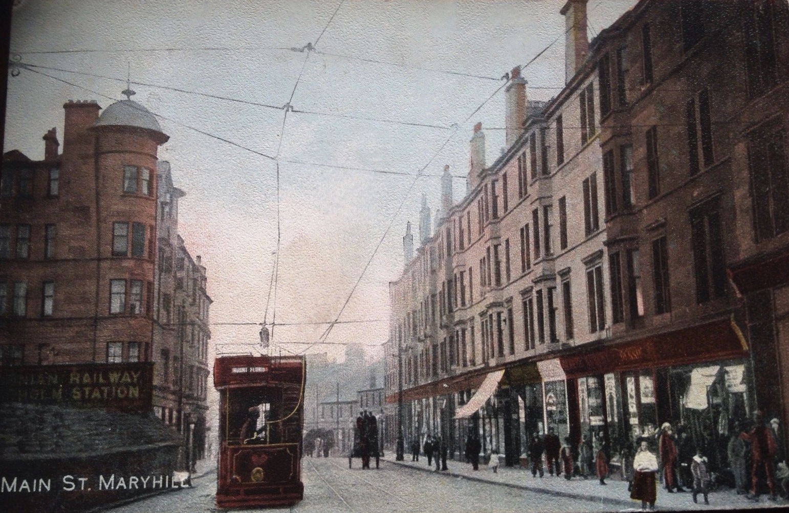
In this postcard, dated July 1906, the tramcar is headed down Main Street, Maryhill on the long journey south to Mount Florida. It is about to pass the fine tenement building on the left, on which the letters of Maryhill Cross in red sandstone were attached.
Nithsdale Cross
Set amidst the opulence of late Victorian and Edwardian stone mansions, Nithsdale Cross in Pollokshields is located at the intersection of Nithsdale Road and St. Andrew’s Drive. Even though it was served by trams, Nithsdale Cross was, and still may be, one of Glasgow’s least trafficked crosses because of its purely residential location.
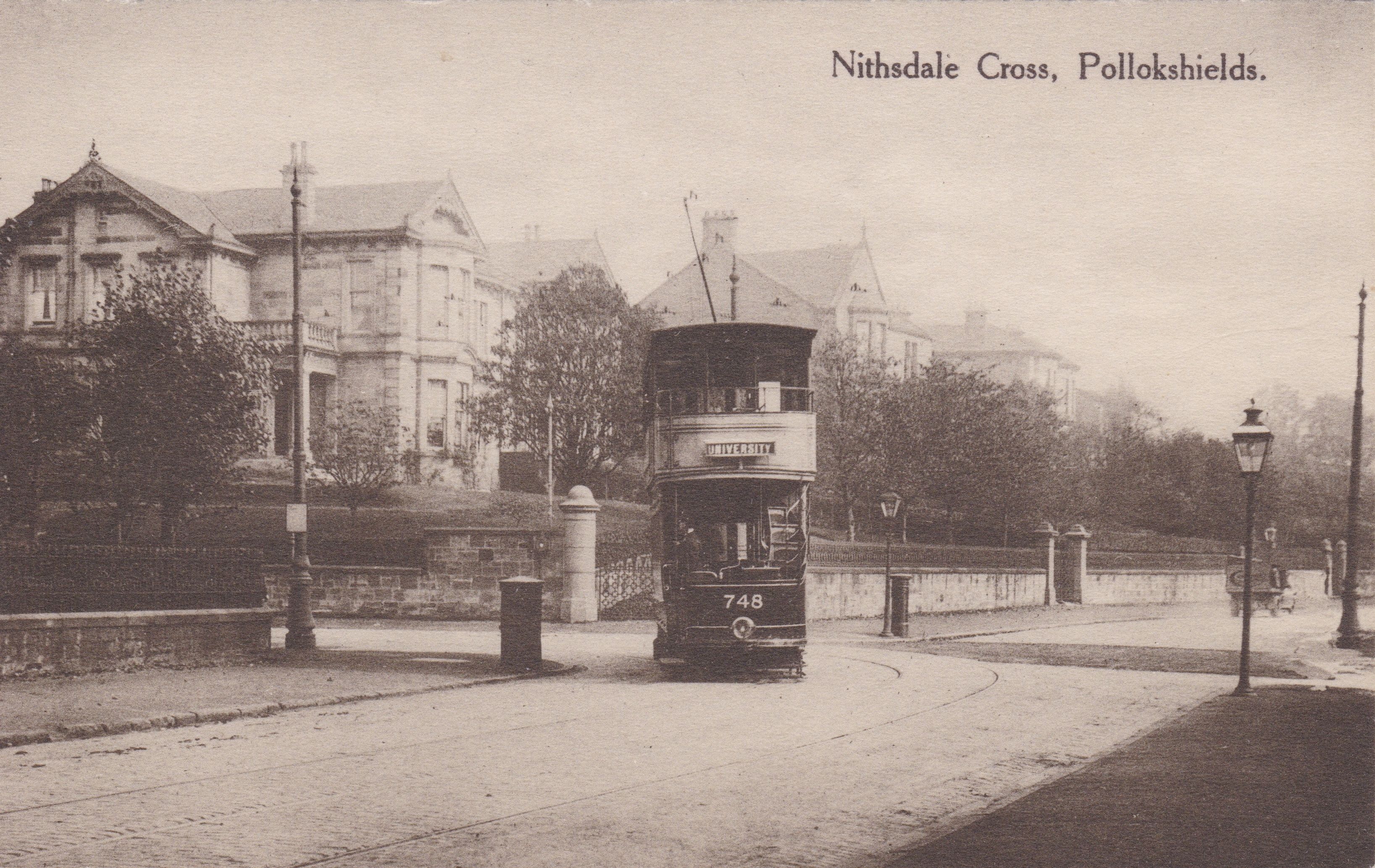
This scene dates from around 1911 and shows a “white” tramcar at Nithsdale Cross en route to the University.
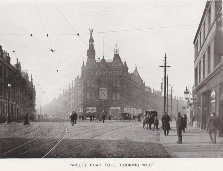
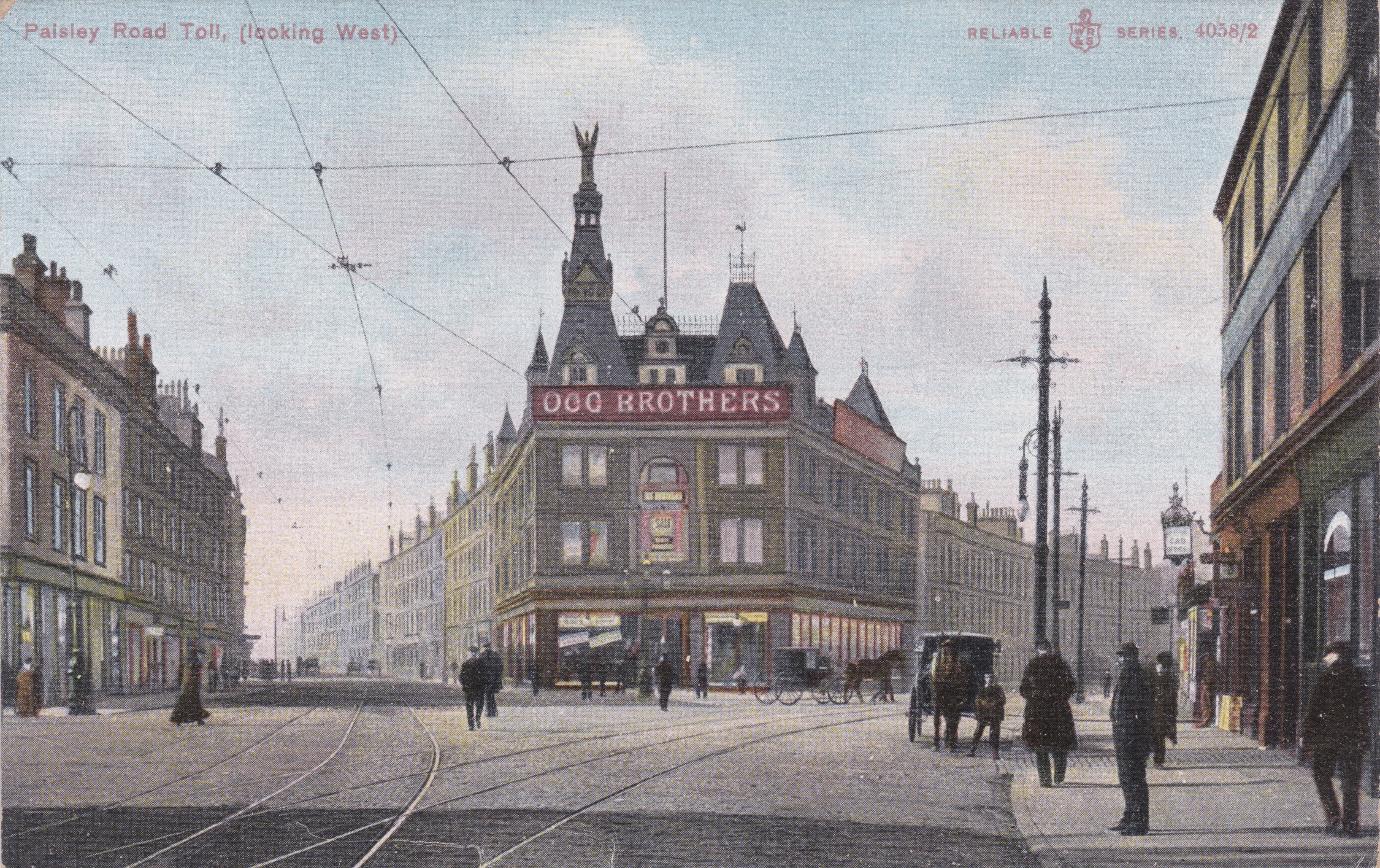
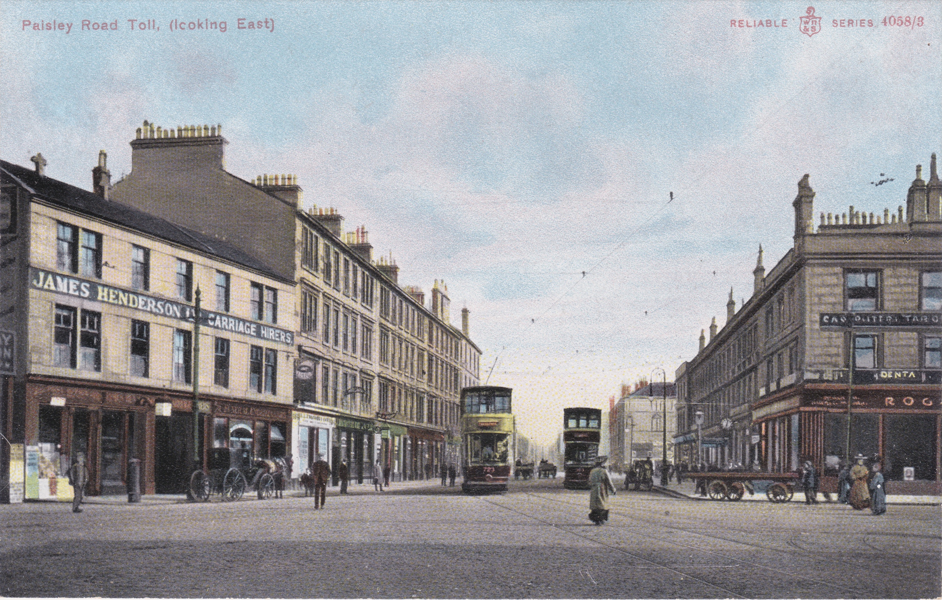
Paisley Road Toll – Located where Paisley Road branched into Paisley Road West and Govan Road. Great Wellington Street joined the Toll from the south.
Parkhead Cross
Parkhead Cross is the site of a major road junction on the east side of Glasgow where New Road, Westmuir Street, Burgher Street and Dalmarnock Street met the Great Eastern Road passing though the place where Parkhead began. New Street was subsequently renamed Duke Street and Dalmarnock Street renamed Springfield Road. The section of Great Eastern Road west of Parkhead Cross became an extension of the Gallowgate around 1925, and east of Parkhead Cross it was renamed Tollcross Road.
Parkhead grew from a small weaving village at the junction of the Great Eastern Road and Westmuir Street into an industrial powerhouse following the discovery of coal in the area in 1837.
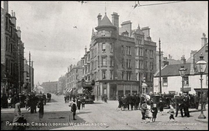
Here, we are looking west along Great Eastern Road in the first years of the 20th Century. Notice the large number of people gathered at the Cross, including many barefoot children.
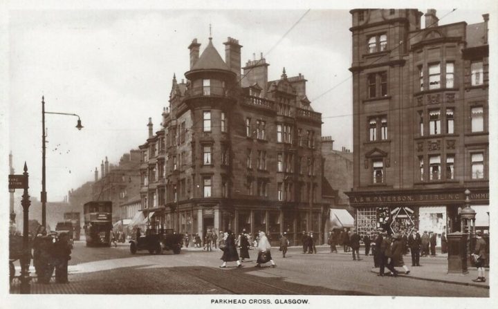
There have been many changes in the intervening years. The large gas lanterns have been replaced by electric street lights and the type seen here were introduced in the early 1930’s so they may have replaced an earlier design. The whitewashed dwelling in the right foreground has been replaced by the fine red sandstone tenement building and what used to be Great Eastern Road on the left is now an extension of the Gallowgate. The wrought iron fountain is, however, still in place. The street names at Parkhead Cross would now be, in clockwise order; Gallowgate, Duke Street, Westmuir Street, Tollcross Road, Burgher Street, and Springfield Road. ( Postcard published by J.M. & Co. in the Caledonia Series. )
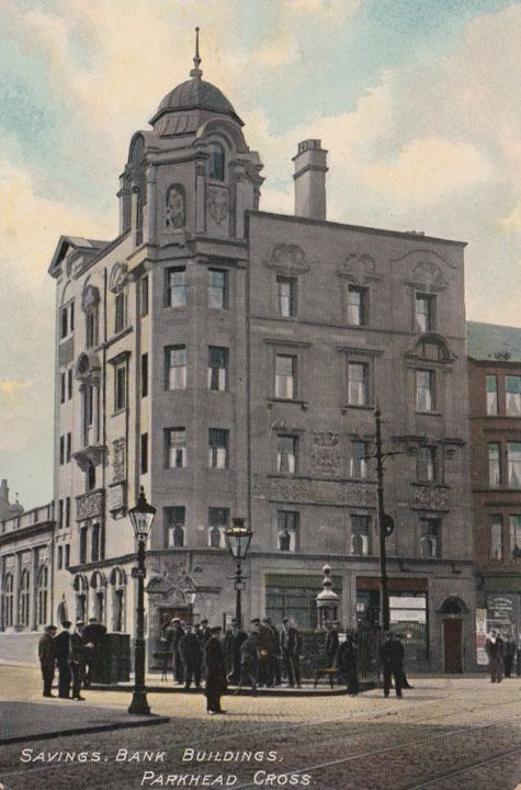
Here, we are looking across the tram lines on Great Eastern Road to the Savings Bank on the corner with Burgher Street.
Partick Cross
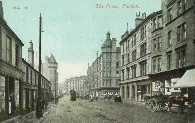
In this view, we are looking west along Dumbarton Road towards Partick Cross, circa 1910. The distinctive dome of Partick Cross Mansions indicates the location of the Cross and Byers Road enters on the near side.
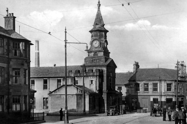
Pollokshaws Cross
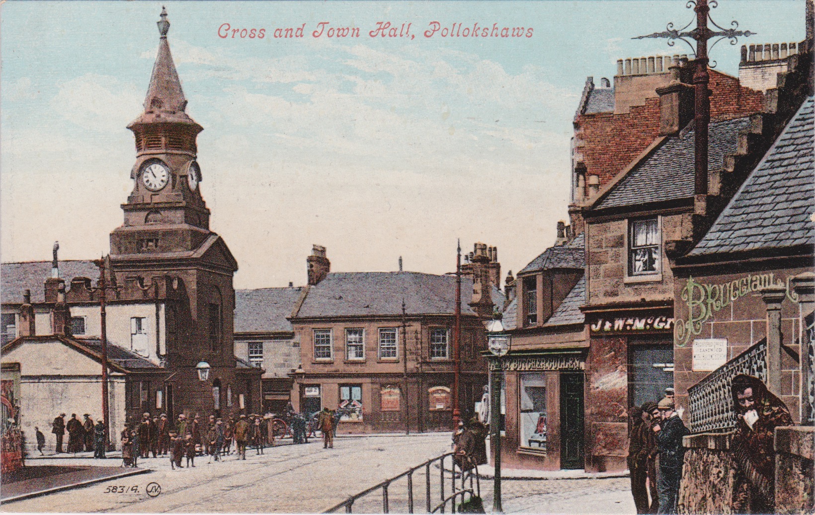
This early 20th century scene depicts Pollokshaws Town Hall with its clock tower, and the Cross, which is the area in front of the Town Hall where five streets meet. These streets are also indicated in the map below. The photograph is taken from Pleasance Street, and Shawhill Street is entering on the right. Pollok Street comes in at the top, and MacArthur and Main Streets enter on the left. Pollokshaws Cross is not indicated on maps of the period and this may suggest that the Cross was more of a local term of recognition. ( Postcard published in Valentine’s Series. )
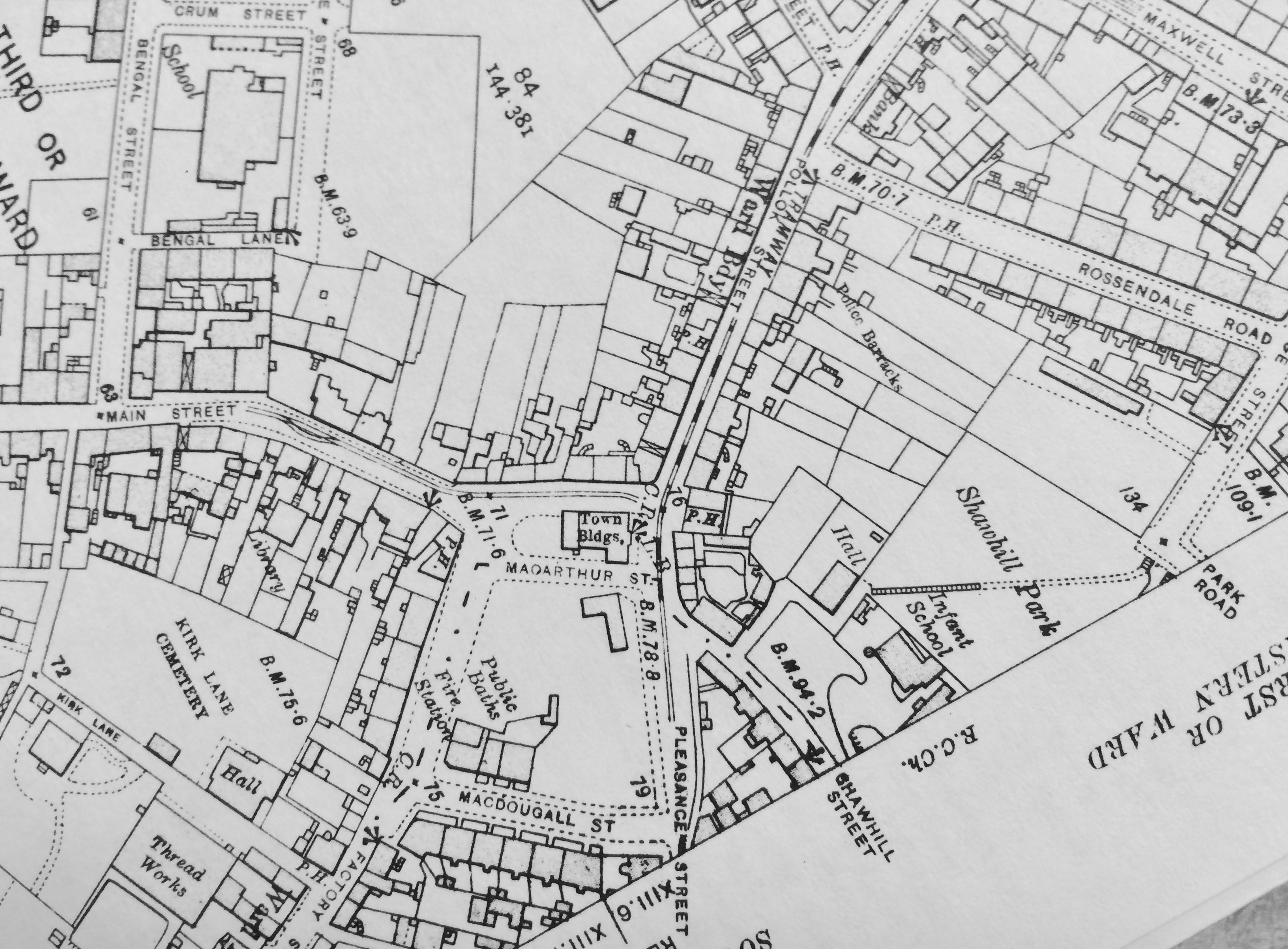
This view of Pollokshaws Town Hall and the Cross probably dates from the early to mid-1930’s. Trams ran along Pleasance Street and Pollok Street and there was a branchline and terminus in Main Street, as shown on the map above.
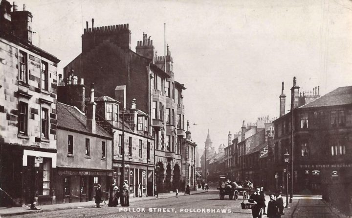
In this early 20th Century Pollokshaws scene, we are looking along Pollok Street towards the Cross and the Town House with the clock tower. Buildings line both sides of the street and their ages are probably related to the number of storeys, with two storeys indicating the earliest buildings, and four storeys being the newest. When viewed today, this scene has changed radically. Only the Town House tower and the four-storied building with the arches remain. Even the street name has changed and this is now Greenview Street. ( Postcard published by Philco and postmarked 1919.)
Possil Cross – Situated in Hamiltonhill to the north of Port Dundas, and at the junction of Possil Road, Saracen Street, Keppochhill Road, and Craighall Road.
Queen’s Cross – Located at the junction of New City Road and Garscube Road with Gairbraid Street. Gairbraid Street and the upper section of New City Road have since been renamed Maryhill Road.
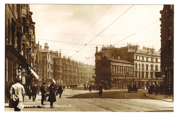
This view from Gairbraid Street shows the entrance to Garscube Road on the left and New City Road on the right. Queen’s Cross Church, designed by Charles Rennie Mackintosh, is just visible near the lamp standard on the left.
St. Andrew’s Cross
The principal cross at this location is in the form of a saltire, which may be why it was named after St. Andrew.
St. Andrew’s Cross was formed by the intersection of Pollokshaws Road with Victoria Road and the latter’s continuation into Eglinton Street. Once the separating fence was constructed in 1946, the Cross was no longer operational and the location became more familiarly known as Eglinton Toll.
St. George’s Cross
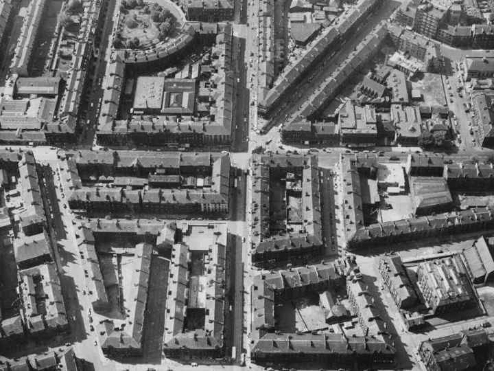
The location of St. George’s Cross is identified in this aerial view as the V shape in the upper part of the photograph. To the left of the V is Great Western Road and to the right is New City Road which was subsequently renamed Maryhill Road. New City Road also continues below St. George’s Cross. Crossing the base of the V from left to right is St. George’s Road, which we saw earlier connecting with Sauchiehall Street at Charing Cross.
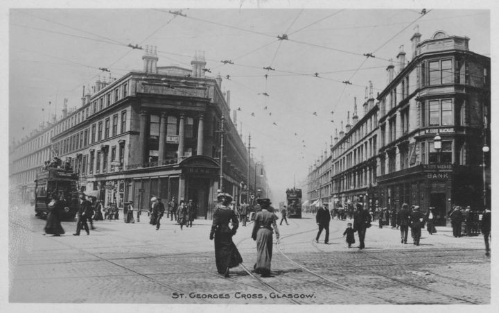
This photograph was probably taken very soon after the tramway system was electrified at this location in 1901/02 and late Victorian fashion is still very much on display as the two ladies in the foreground stride confidently across this wide intersection. The street on the left is Great Western Road and on the right is New City Road.
St. James Cross – Located at the junction of St. James Road and Stirling Road.
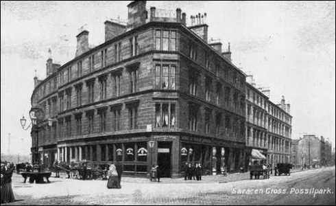
Saracen Cross – This is where Balmore Street and Bardowie Street join Saracen Street in Possilpark.
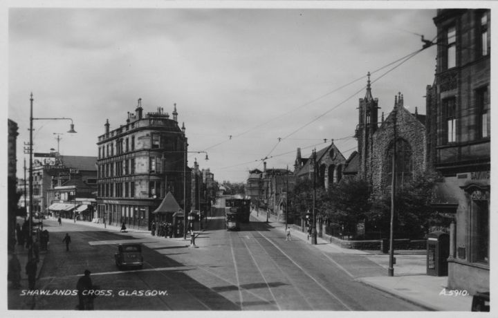
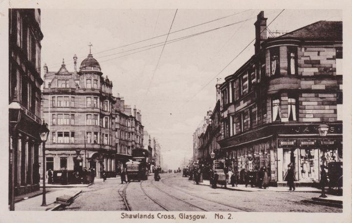
Shawlands Cross
Shawlands Cross is located at the junction of Pollokshaws Road with Kilmarnock Road and not, as might have been expected, at the cruciform junction of Pollokshaws Road with Langside Avenue and Minard Road.
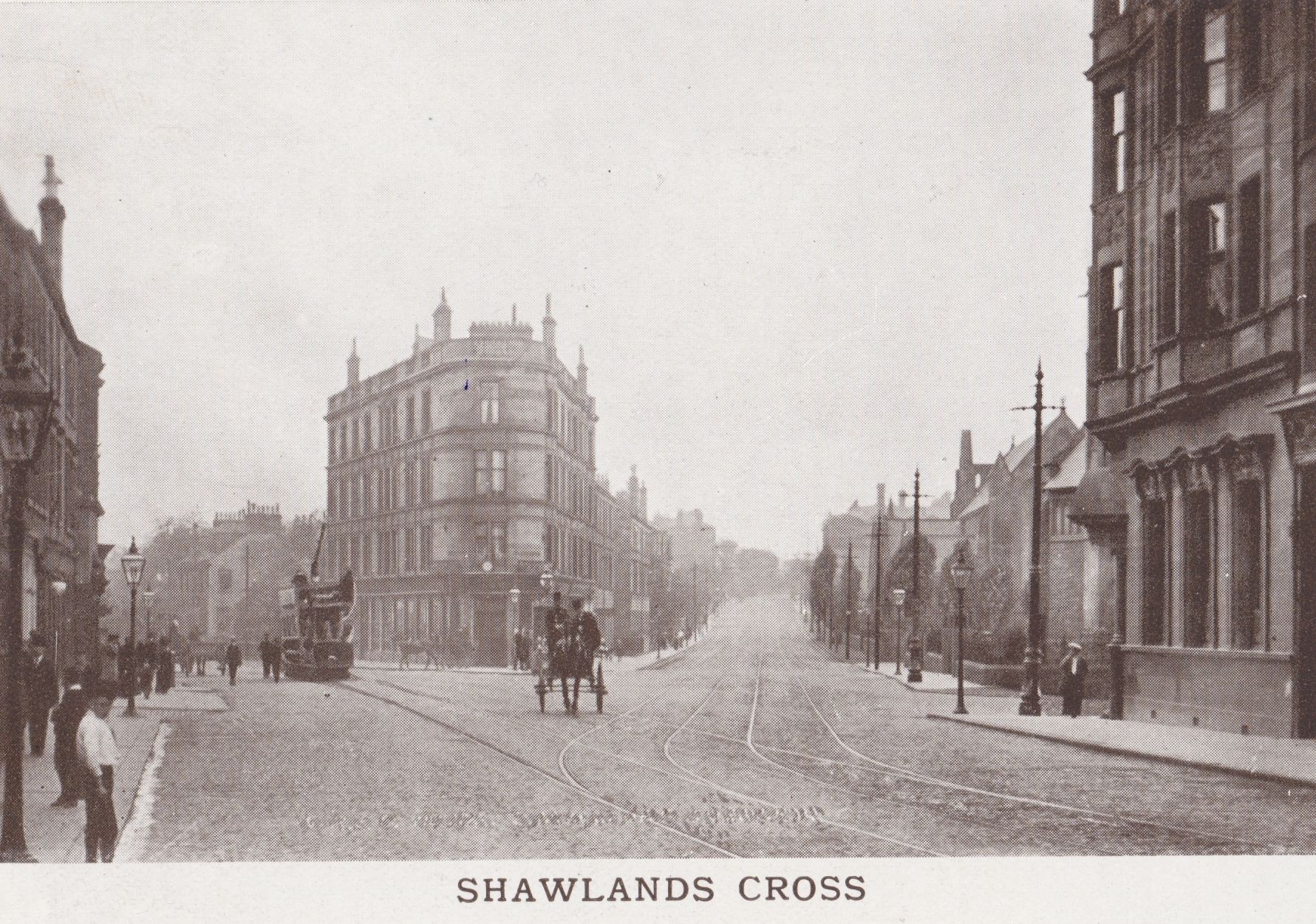
The eastern approach to Shawlands Cross is via Pollokshaws Road from where this photograph was taken in the early 1900’s. At the Cross, the road branches, with Pollokshaws Road continuing on the right and Kilmarnock Road leading off to the left. The street going off to the right in the foreground is Moss-side Road. The United Free Church on the corner of Moss-side Road and Pollokshaws Road is not visible in this picture but it can be seen in the photograph below. The church that is visible here is Shawlands Parish Church which was built between 1885 and 1889.
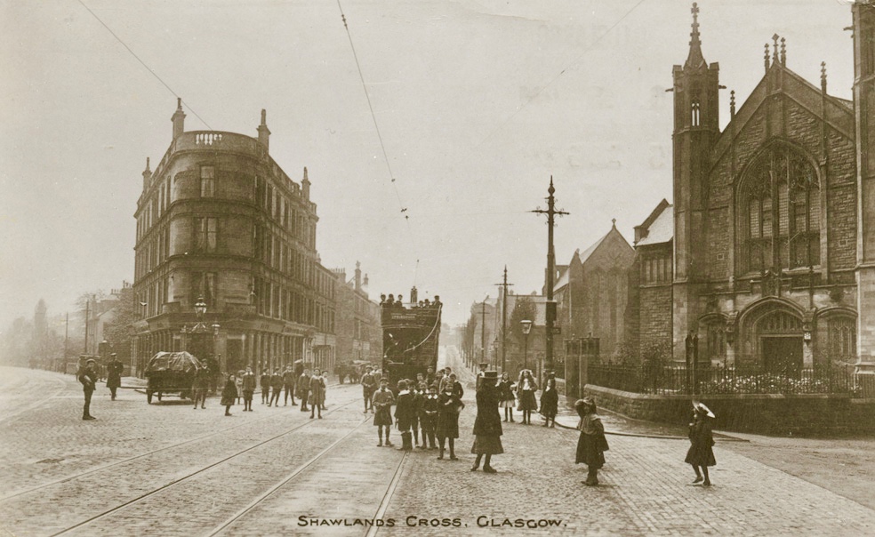
Well-dressed children are waiting outside the Shawlands United Free Church at Shawlands Cross on the occasion of an outing, perhaps with their Sunday School, and for which the tramcar in the picture has probably been reserved.
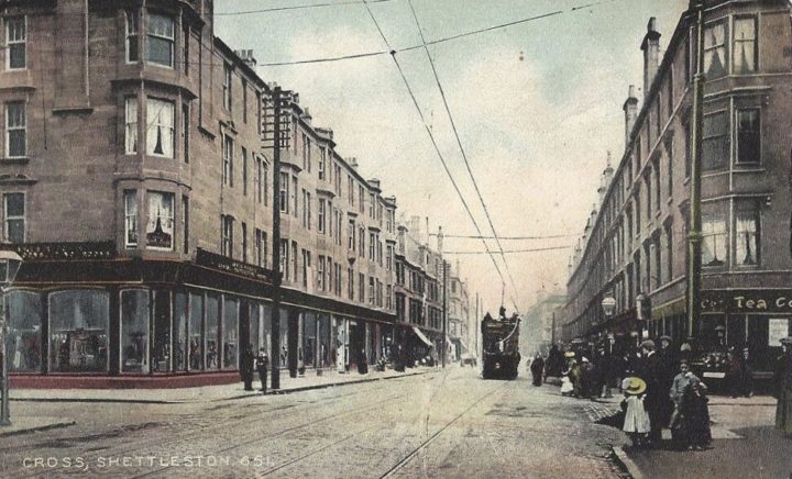
Shettleston Cross – A cruciform cross where Darleith Street and Wellshot Road join Shettleston Road.
Springburn Cross – Located at the junction of Cowlairs Road and Vulcan Street with Springburn Road.
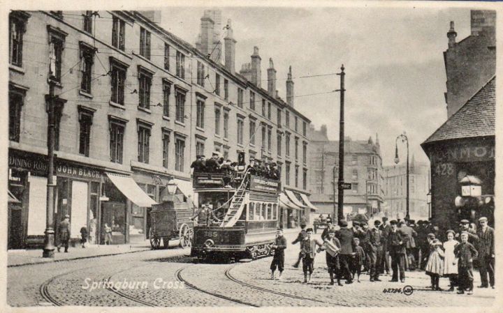
The number 428 identifies this location as the corner of Springburn Road and Vulcan Street, the latter going off to the right. The tram lines do not curve into Vulcan Street but continue south on Springburn Road. Cowlairs Road enters on the left, just off camera, and the row of tenements in view lies between Cowlairs Road and Angus Street. The large gap beyond Angus Street is explained by the railway bridge. The tram in view is bound for Pollokshaws West.
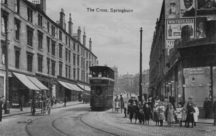
The granite drinking fountain seen here on Vulcan Street at Springburn Cross was presented to Glasgow Corporation by the Cowlairs Co-operative Society on the occasion of their 21st Anniversary in 1902. It now stands in the Springburn Centre. ( Photograph reproduced by kind permission of Ian Todd and the Glasgow Chronicles. )
Strathbungo Cross – Located at the intersection of Allison Street and Pollokshaws Road.
Stobcross
The origin of Stobcross is different from that of the other Glasgow crosses because it does not refer to a crossing place. It is thought to have been named after a wooden cross which was set up on lands that would later become the Stobcross Estate. One of the meanings of stob in Auld Scots is a wooden post.
Tollcross
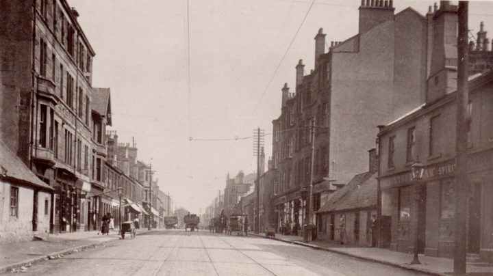
View of Main Street Tollcross, looking East.
The ground on which the present Tollcross stands was originally part of the lands of Schedinestun ( Shettleston ) granted to William Bondington, Bishop of Glasgow, by King Alexander II in 1242. It was much later that the Royal Burgh of Rutherglen was permitted to collect tolls at the Cross of Shettleston which was thought to have been located at the west end of what would later become Tollcross village, a small weaving community. Today, the location would be near the junction of Tollcross and Wellshot Roads. This original Cross of Shettleston is not the same as the current Shettleston Cross. Information obtained from www.glasgowhistory.co.uk/Books/Tollcross&Dalbeth/TollcrossCHapters/HistoricalBack.htm
Townhead Cross – Located at the junction of Castle Street with Alexandra Parade.
Victoria Cross I – Located at the junction of Victoria Road and Allison Street.
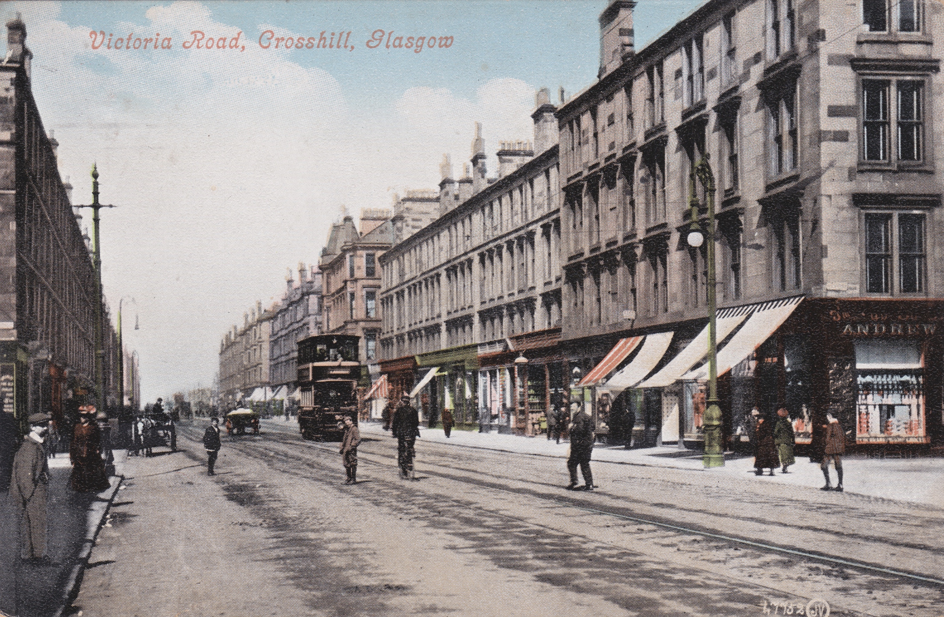
In this view, we are looking up Victoria Road in the direction of the city and have just passed the entrance to Queen’s Park Station on the left. The intersection just beyond the tramcar is the location for Victoria Cross in Govanhill, where Allison Street crosses Victoria Road.
Victoria Cross II – Located where Albion Street and Parkville Road joined Byers Road. Albion Street in Dowanhill has since been renamed Dowanside Road and Parkville Road is now called Ashton Road.
Whiteinch Cross
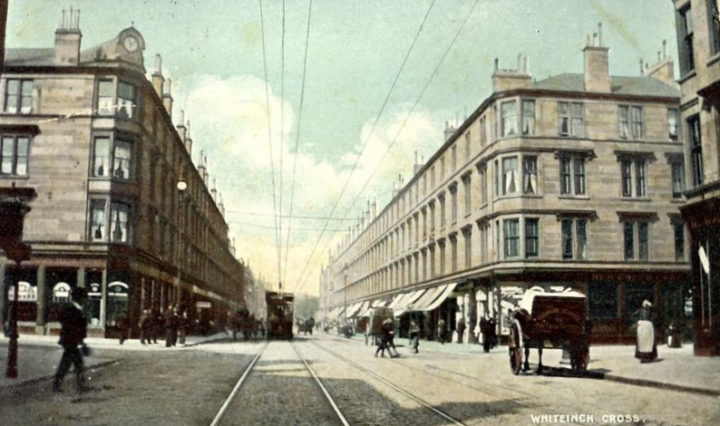
Approaching Whiteinch Cross on Dumbarton Road with Gordon Street on the left and Smith Street on the right. Gordon Street has since been renamed Glendore Street and the tenement block on the left is still standing although the chimney stacks and the clock are no longer present.
{ 1 trackback }
{ 9 comments… read them below or add one }
Do you know of Victoria Cross on Byres Road?
Interesting Story.
Plans to rename the junction of Byres Road and University Avenue in advance of a visit by Queen Victoria…..apparently defeated by the people….the name can still be seen on the building to the north of Tennent’s Bar.
Marc
Hi Marc,
Thank you for your question. It forced me to do further searching and I came up with not one but two Victoria Crosses and a host of others to add to the list!
Chris
Hi Chris,
Love the site. I’m chair of the Arlington Baths Club. Owned and run by members since 1870. We’ve some great archive photos we’d be happy to share with you. If you reckon the city’s first swimming baths club might be worth adding, get in touch and we’ll do what we can to help.
All the best.
Gordon
PS Pop in during Doors Open Days if you are passing.
Hi Gordon,
Many thanks for sharing this information and for your kind offer. I see that Arlington Baths Club has its own website; arlingtonbaths.co.uk I spent a good part of my youth swimming in Glasgow baths, initially at Calder Street and then at the Gorbals Baths where I also learned Life Saving from the Glasgow Police. Many happy memories.
Best wishes,
Chris
Hello,
Great pictures of Glasgow’s past. Would you know the dates of the Shettleston and Tollcross pictures? Thanks.
Paul
Hi Paul,
Thank you, and I would estimate the dates of the Shettleston and Tollcross images to be sometime between 1901 and 1904.
Best wishes,
Chris
Hi Chris,
Memories of those locations are still present. I lived in Kingsway and studied at Anniesland College. I always wondered why it was called Anniesland Cross.
Omar
Hi Chris,
A long time ago, possibly when studying history at school in Scotland, I was told that the name “Charing” in the London Cross of that name, came from “Chere reine”, as Eleanor was Edward’s beloved queen.
Great photos of Glasgow.
Mary.
Hello Mary,
Thank you for your comment and yes, I had read about this possible origin of the name Charing. However, I understand that it is now thought to have pre-dated the passing of Edward’s beloved Queen Eleanor by about 100 years.
I’m glad you like the photos.
Best wishes,
Chris